submitted
published
2026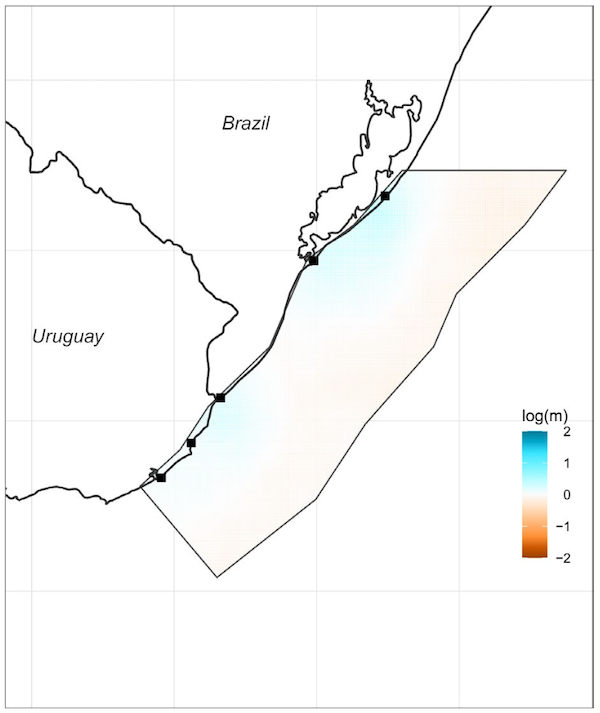
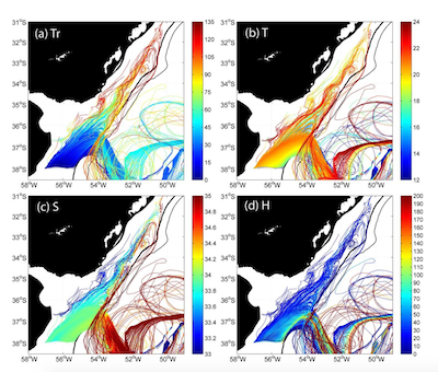
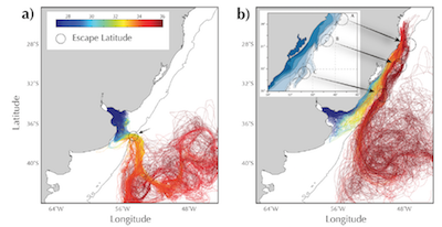
Abstract: Bio-oceanographic modeling and population genomics were combined to assess connectivity of the blue crab Callinectes sapidus in the Southwestern Atlantic Ocean, with particular attention to the scale of its fishery management, and the potential role of Marine Protected Areas (MPAs) in Uruguay as larval source zones. A bio-physical model, coupled with hydrodynamic outputs of a model experiment, incorporated larval vertical migration behavior and key species-specific traits to simulate dispersal pathways across the region. Population structure was assessed by using SNPs variability. Both approaches revealed substantial connectivity among sampled locations. Genomic population genetic analysis supported a single, well-mixed population across the study area, consistent with the extensive dispersal predicted by the model. These results highlight the need for management strategies tailored to the species' population structure and emphasize the importance of binational (Brazil-Uruguay) coordination for this transboundary fishery, which is already showing clear signs of overexploitation. Model simulations further showed that Uruguayan MPAs may act as important larval sources, particularly during winter recruitment under La Niña conditions, exporting propagules to non-protected areas in southern Brazil. By resolving the spatial and temporal scales of larval exchange, this study enhances regional understanding of connectivity patterns and supports evidence-based conservation planning for C. sapidus.
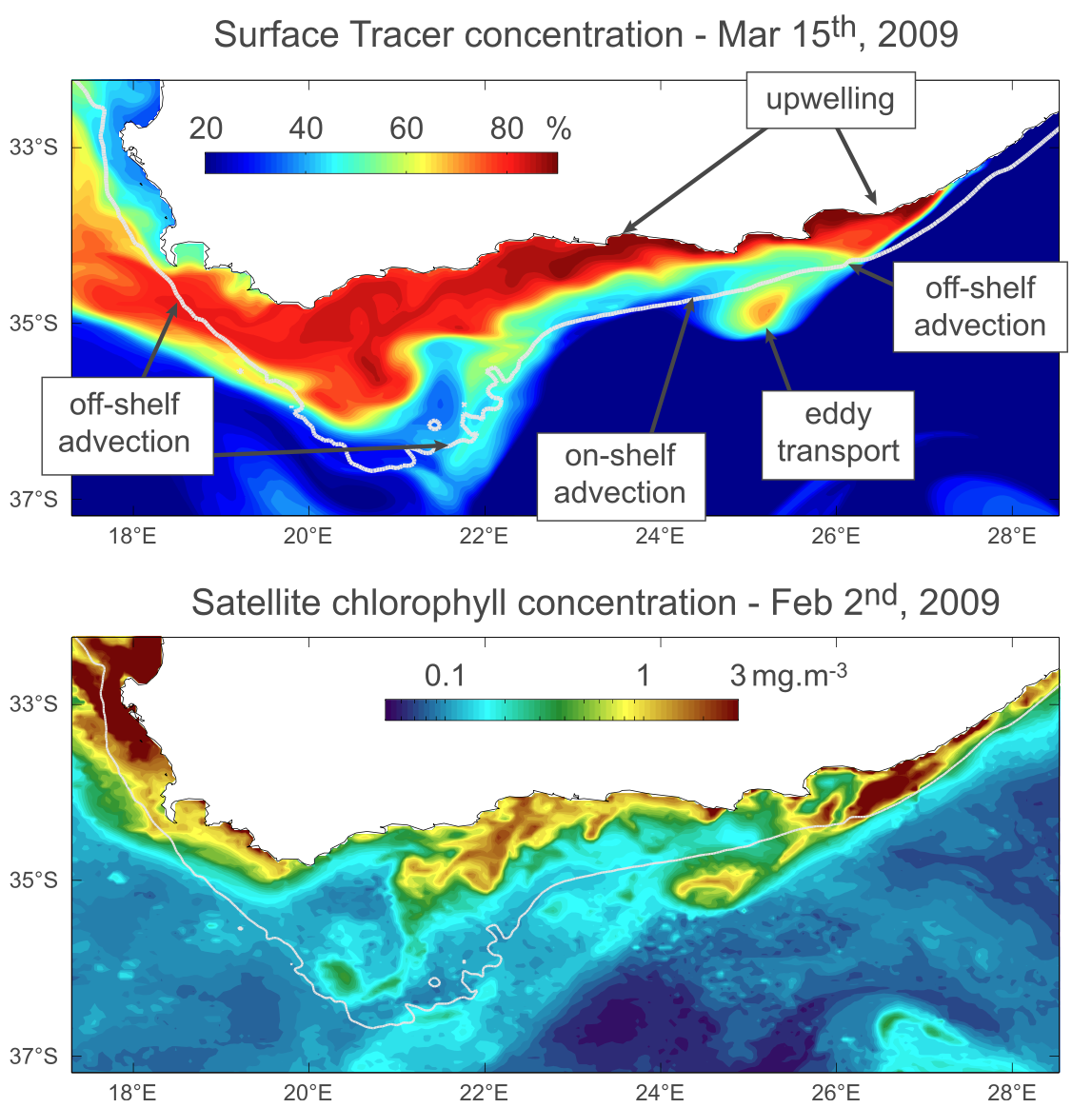
Abstract: This modeling study investigates the variability of the Agulhas Bank (AB) circulation, focusing on its connections to the local wind forcing and the Agulhas Current (AC) as well as to teleconnections to the tropical South Atlantic. The mean AB circulation is dominated by a westward flow composed of a coastal jet, an outer‐shelf flow influenced by AC intrusions, and a strong mid‐shelf jet shaped by both wind and AC dynamics. Empirical Orthogonal Function analyses of sea surface height (SSH) and temperature reveal patterns strongly linked to AC position and wind variability, with significant correlations between SSH anomalies and AC displacements. Passive tracer experiments show that while AC‐driven vertical transport can uplift deeper waters onto the shelf, wind‐driven upwelling and mixing are critical for surface expression. Tracer distribution is modulated by both wind and AC transport with contrasting spatial impacts. Furthermore, the study identifies a teleconnection with the tropical South Atlantic, as coastal trapped waves propagate interannual SSH variability southward, though their influence on AB circulation appears limited in dynamic significance. Overall, AB circulation emerges as a complex interplay of local and remote forcings, with variability largely governed by the AC and wind, and modulated by occasional tropical signals.
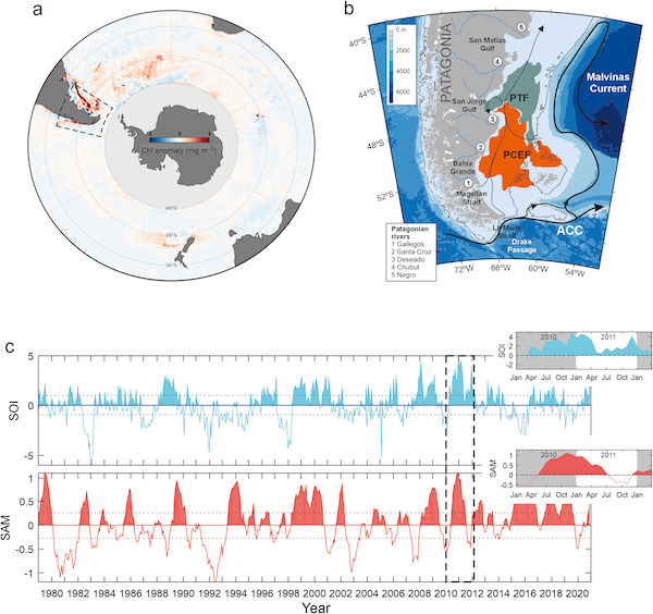
Abstract: Between mid-2010 and early 2012, the Southern Patagonian Continental Shelf (SPCS) experienced an exceptionally intense and persistent phytoplankton bloom, during which chlorophyll-a (Chl-a) concentrations doubled the climatological mean during the austral autumn and winter. As a result, annual Chl-a levels exceeded the long-term average by more than 80%. Here, we investigate the climatic and oceanographic drivers underlying the magnitude and duration of this anomalous event. Using 24 years of ocean color observations combined with atmospheric reanalysis data and hydrodynamic model outputs, we identify large-scale atmosphere-ocean coupling associated with the concurrent multi-year La Niña (LN) and positive Southern Annular Mode (SAM) phases as the dominant driver of the extraordinary bloom. At the regional scale, this sustained climate event enhanced wind-driven exchange between western and eastern Patagonia, promoting the intrusion of low-salinity (<34.5), potentially nutrient-rich Pacific water through the Magellan Strait into the Atlantic Ocean (>0.12 Sv). Additional processes, including episodic wind weakening over the SPCS, a reduced autumn-winter mixed layer depth (MLD), and associated modifications of the northward-directed shelf and offshore transport, likely further enhanced phytoplankton production, distinguishing this event from other comparable climatic episodes. These findings highlight the critical role of interactions between major climate variability modes in shaping ocean productivity in the SPCS.
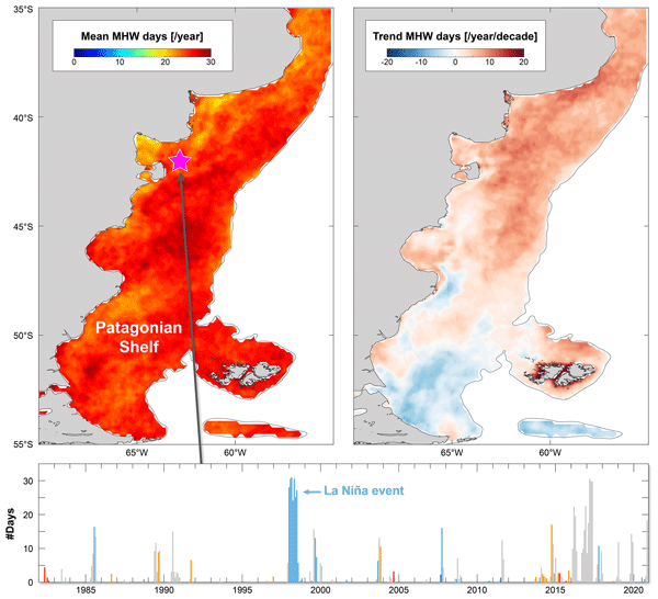
Abstract: Marine heatwaves (MHWs), have doubled in frequency globally in recent decades and are becoming longer, more intense, and increasingly disruptive to marine ecosystems. However, despite their growing ecological and biogeochemical importance, major productive coastal systems remain understudied, particularly in the Southern Hemisphere. Here, we provide the first comprehensive characterization of MHWs across the Patagonian Shelf (PS), one of the most biologically productive marine regions on Earth, using 40 years of satellite-derived daily sea surface temperature (SST) data. We first assess how the choice of MHW detection method (fixed versus moving climatology) and SST-dataset selection affect MHW metrics. Then we quantify MHW frequency, intensity, duration, and long-term trends, revealing that the PS experiences on average 1.9 ± 2 MHWs yr−1 with a mean cumulative duration of 23–28 d yr−1 and an average intensity of 1.36 ± 0.3 °C. We show that MHW activity varies substantially across the region, with the northern sector and the outer shelf experiencing the most frequent and intense events (>2 events yr−1 and >2 °C). A notable increase in MHW days (+5–10 d per decade) is observed in the northern PS, whereas no significant trends are observed to the south (i.e., south of 48° S). These trends are consistent with background warming of the ocean in this region, suggesting a mechanistic link, whereby long-term warming enhances the likelihood of MHWs occurrence and duration. We further demonstrate that a component of MHW variability can be attributed to the El Niño Southern Oscillation, which exerts a stronger influence on the intensity of thermal anomalies than on the cumulative duration of the events. Together, these findings constitute the first comprehensive assessment of MHWs on the PS and provide essential insight for anticipating their ecological and climatic impacts in one of the Southern Hemisphere's key marine ecosystems.
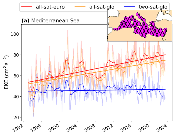
Abstract: Mesoscale activity plays a central role in ocean variability, substantially influencing the mixing of biogeophysical tracers, such as heat and carbon, and driving changes in ecosystems. Eddy Kinetic Energy (EKE), a metric used for studying the intensity of mesoscale processes, has recently been shown to increase in regions of intense EKE worldwide. Strong EKE positive trends are observed, for example, in the principal western boundary current regions, such as the Gulf Stream, Kuroshio Extension, and the Brazil/Malvinas Confluence. In this study, we assess whether the Mediterranean Sea, known to be a hotspot for climate change impacts, also exhibits such intensification. Despite the high number of observational data and modeling experiments, there is a gap in understanding the long-term evolution of mesoscale dynamics and EKE trends in the Mediterranean Sea. This study investigates EKE trends in the Mediterranean Sea using daily geostrophic currents derived from satellite altimetric data. To test the robustness of the results, we compare EKE trends computed from three different gridded altimetric products: a global product derived from a stable two-satellite constellation (two-sat) and two other products (global and European) incorporating all available satellites (all-sat). While all products reveal a general increase in EKE in the Mediterranean Sea over the last three decades, the trends calculated from the two-sat product are significantly smaller than those computed from the all-sat products. We show that this discrepancy is strongly linked to the increasing number of satellites over time used to construct the all-sat data sets, which enhances both spatial and temporal coverage, and hence, their capacity to detect higher energy levels. To evaluate the fidelity of these gridded products in capturing EKE trends, we compare them with along-track data in high-energy regions of the Mediterranean Sea: the Alboran Sea and the Ierapetra area. These regions exhibit contrasting EKE trends: positive in the Alboran Sea and negative in the Ierapetra area. These findings highlight the importance of using altimetric products with a stable number of satellites constructed for climate applications when addressing long-term ocean variability analysis.
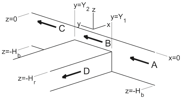
Abstract: The influence of a subsurface ridge on a subinertial coastal Kelvin wave is investigated using a numerical model and a simplified analytical framework. A first baroclinic mode Kelvin wave is made to impinge on progressively complex subsurface geometries. For an idealized submerged shelf that extends infinitely in both offshore and alongshore directions, the over‐shelf response includes low vertical modes of the shallower domain and an upward‐propagating beam from the shelf‐top corner, inducing alongshore variability in the shelf flow. When the alongshore extent is truncated to form a ridge between two deep basins, the downstream response strongly depends on ridge width. Phase patterns reveal upward and downward energy propagation from the downstream ridge corner, along with horizontal propagation of multiple vertical modes. As the ridge narrows, beam amplitudes decrease, though vertical propagation remains visible in phase patterns. If the ridge width is less than approximately twice the Rossby radius of deformation of the ridge‐top domain, evanescent modes along the ridge flanks begin to overlap and interact, promoting more horizontal energy transmission into the downstream basin. Thus, the Rossby radius of deformation sets a natural scale governing the balance between vertical scattering and horizontal transmission. In the most realistic configuration, a submerged ridge of finite offshore and alongshore extent, waves trapped to and propagating around its periphery affect the downstream basin through combination with the signals that propagate over the top of the ridge.
2025
Abstract: This chapter evaluates the impacts of climate change on the Southwestern Atlantic Shelf (SWAS) circulation, a region extending from Cabo Frio, Brazil (~28°S) to the tip of Tierra del Fuego, Argentina (~55°S). Satellite observations reveal a widespread warming trend across the SWAS, peaking at 0.31°C per decade in the South Brazil Bight, accompanied by a sea level rise of approximately 3 mm per decade. Analysis of CMIP5 simulations indicates an intensification of the Brazil Current transport and a weakening of the Malvinas Current transport, resulting in distinct warming and freshening patterns in the upper ocean. Complementary downscaling experiments further suggest that the northern and central SWAS will experience the most significant impacts due to increased on-shelf flow of Brazil Current waters. In contrast, climate change impacts on the southern region are projected to be substantially smaller, with downscaling experiments showing a reduced inflow of subantarctic waters through the Drake Passage. Consequently, this study concludes that changes driven by projected emissions are likely to exacerbate warming and salinification in the northern and central shelf areas, with broad implications for local marine ecosystems and human activities.
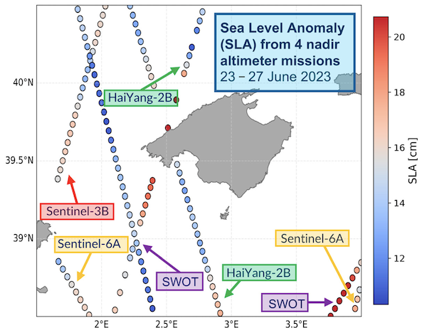
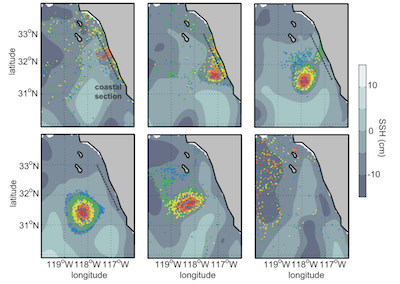
Abstract: Mesoscale coastal eddies are key components of ocean circulation, mediating the transport of heat, nutrients, and marine debris. The Surface Water and Ocean Topography (SWOT) mission provides high-resolution sea surface height data, offering a novel opportunity to improve the observation and characterization of these features, especially in coastal regions where conventional altimetry is limited. In this study, we investigate a mesoscale anticyclonic coastal eddy observed southwest of Mallorca Island, in the Balearic Sea, to assess the impact of SWOT-enhanced altimetry in resolving its structure and dynamics. Initial eddy identification is performed using satellite ocean color imagery, followed by a qualitative and quantitative comparison of multiple altimetric datasets, ranging from conventional nadir altimetry to wide-swath products derived from SWOT. We analyze multiple altimetric variables—Sea Level Anomaly, Absolute Dynamic Topography, Velocity Magnitude, Eddy Kinetic Energy, and Relative Vorticity—highlighting substantial differences in spatial detail and intensity. Our results show that SWOT-enhanced observations significantly improve the spatial characterization and dynamical depiction of the eddy. Furthermore, Lagrangian transport simulations reveal how altimetric resolution influences modeled transport pathways and retention patterns. These findings underline the critical role of SWOT in advancing the monitoring of coastal mesoscale processes and improving our ability to model oceanic transport mechanisms.
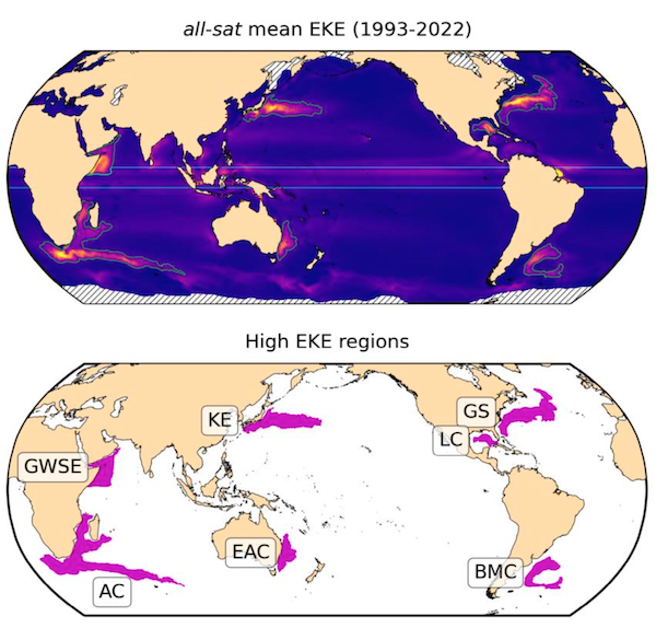
Abstract: Ocean mesoscale variability, including meanders and eddies, is a crucial component of the global ocean circulation. The Eddy Kinetic Energy (EKE) of these features accounts for about 90% of the ocean’s total kinetic energy. This study investigates if the global ocean mesoscale variability is becoming more energetic by analyzing 30 years of satellite altimetric observations. We use two observational products: one constructed from a consistent pair of altimeters and another including all available missions. Our results reveal a significant global EKE strengthening of 1–3% per decade. The intensification is concentrated in energetic regions, particularly in the Kuroshio Extension and the Gulf Stream, which show EKE increases of ~50% and ~20%, respectively, over the last decade. These observations raise new questions about the impact of the Gulf Stream strengthening on the Atlantic meridional overturning circulation (AMOC) and challenge existing climate models, emphasizing the need for improved representation of small-scale ocean processes.
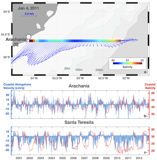
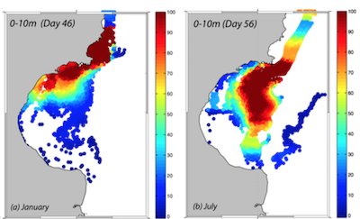
Abstract: The wedge clam, Donax hanleyanus, inhabits sandy beaches in the subtropical and temperate regions of the Atlantic coast of South America. Its distribution spans over 20 degrees of latitude from Brazil to Argentina, with the southernmost part of its range being influenced by the Rio de la Plata (RdlP) estuary, which limits the southward larval expansion. We used an individual-based model (IBM) to assess the larval connectivity patterns of the wedge clam during the period 2000-2012. The IBM combines a 3D hydrodynamic model with a biological sub-model that considers larval mortality due to low salinity (< 7, and > 9) and sea surface temperature range (high > 30°C or low < 9°C). The main larval connectivity patterns were observed near the release/recruitment areas, suggesting a high potential for self-recruitment. Based on the IBM and adult abundance data, we also identified the likely source and sink areas within this metapopulation. Source beach areas were Navegantes and Cassino in Brazil (from 26.3° S to 34.34°S), Arachania in Uruguay (34.56°S), and Santa Teresita in Argentina (37.15°S). A low probability of larval transport towards the poleward limit of the species' distribution was observed, supporting an irregular recruitment pattern typical of sink populations located at the edge of the distribution range of metapopulations. Larval mortality due to warm or cold waters did not affect connectivity patterns for this subtropical species. Southward larval transport across the RdlP estuary (from Uruguayan to Argentine beaches) only occurred for larvae released on early January 2011, concurrently with the strongest La Niña year observed during the study period. In light of a changing climate, marked by potential increases in extreme La Niña events and a poleward shift of atmospheric circulation patterns over the South Atlantic, we anticipate a strengthening of larval transport across the RdlP and a subsequent poleward expansion of the species’ distribution range.
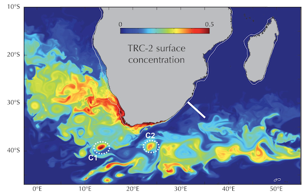
Abstract: This modeling study analyzes the circulation over the AgulhasBank (AB). It is suggested that the time mean circulation over the bank is primarily driven by the inflow of shelf waters from the northeastern region, and not by local forcing as previously postulated. Seasonal variations of the circulation and temperature and salinity fields are highly correlated with the atmospheric forcing. Currents shift inshore during the winter, returning to its original position during summer. The equatorward flow in the western AB, which includes a deep, previously unreported, countercurrent, strengthens during spring and summer and wanes during fall and winter. Tracer diagnostics and Eulerian mass balances reveal very energetics mass exchanges between the eastern AB and the Agulhas Current (AC). The AB Bight is the preferential site for these exchanges. Lagrangian diagnostic show 0.45 Sv of deep open‐ocean waters entrained into the bottom layer of the shelf. Cross‐shelf exchanges produce significant water mass transformations. Tides play an unexpectedly significant role on the AB circulation. Preliminary considerations suggest that shelf/open‐ocean interactions could have a significant impact on water mass conversions within the AC.
2024
Abstract: The Patagonia shelf-break front presents sharp offshore changes in surface temperature, salinity, chlorophyll, and horizontal velocity shear. In summer, the cross-shore temperature and salinity changes are not uniform, suggesting the existence of multiple fronts. In winter, the offshore changes are fairly uniform, displaying a single thermohaline front located just offshore from the shelf-break. Cross-front temperature and salinity present significant seasonal variations associated with intense vertical stratification over the shelf during summer. The thermocline provides a density interval for cross-front isopycnal exchange, which may fertilize the outer shelf waters. The salinity front extends from the surface to the bottom and is observed year-round. Frontal displacements occur throughout the water column. The high surface chlorophyll along the front suggests a sustained nutrient flux to the shelf-break upper layer. Numerical experiments indicate intense frontal upwelling mediated by the interaction of the Malvinas Current with the bottom topography and suggest that upwelling in upstream portions of the shelf-break, advected northward along the shelf edge, may further modulate the nutrient fluxes required to sustain frontal productivity. A southward displacement of the northernmost extension of the front observed during the past decades may have biological and biogeochemical impacts.
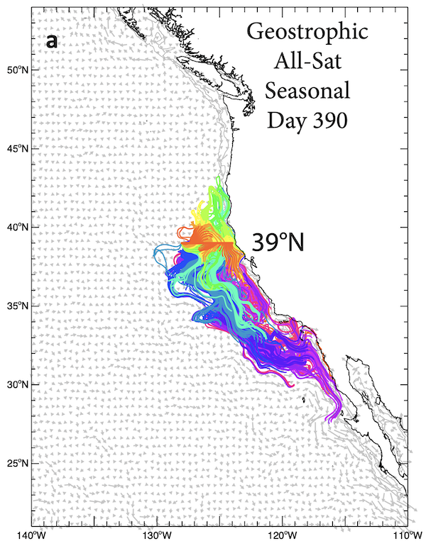
Abstract: We use altimeter-derived geostrophic velocities, with and without the addition of surface Ekman transports, to create trajectories for virtual parcels in the California Current System (CCS). The goal is to investigate the poleward transport of passive water parcels in the surface 50-100 meters of the nominally equatorward system. Motivation for the study is provided by observations of anomalous biomass of copepods with warm water affinities along the Newport Hydrographic Line off central Oregon (44.7°N) during El Niño years, as well as during and following the 2014-2016 Marine Heat Wave. By backward tracking virtual parcels from 44.7°N, we find that the most distant source of passive water parcels in the upper ocean during a one-year period of travel is from within the Southern California Bight (SCB), north of 30°N. To make that journey, parcels use the Inshore Countercurrent off southern and central California during summer-winter and the Davidson Current off northern California and Oregon during autumn-winter. The inclusion of small-scale eddy diffusion usually increases the number of parcels that reach more northern latitudes, while the inclusion of Ekman velocities more often reduces those numbers. Even so, parcels can travel from the SCB to central Oregon in either the Ekman layer or beneath it in the geostrophic flow. Using backward tracking, we find that parcels arrive at 44.7°N most often in winter-spring, least often in autumn. They arrive from within the large-cape region off northern California (41°-42°N) during all years and all months, from just south of the large-cape region (38°-39°N) during most years but seldom in autumn, from south of Monterey Bay along central California (36°N) and within the SCB (34.5°N) during a third (or less) of the years and only in winter-spring. The shortest average transit times are found in winter: for parcels reaching 44.7°N in February, the average transit time is 2 months for parcels coming from 41°-42°N, 4 months for parcels coming from 38°-39°N and 5-6 months or more for parcels coming from south of 36°N. Transit times increase as the year progresses from winter to autumn. The longest average transit times are for parcels reaching central Oregon in autumn (9-12 months in October for parcels coming from south of 39°N). This makes the journey a multi-generational task for the copepods. Interannual variability in the observed southern copepod species biomass correlates highly with years when more virtual parcels from the south reach central and northern Oregon, providing increased confidence in the results found with the altimeter-derived parcel trajectories.
2023
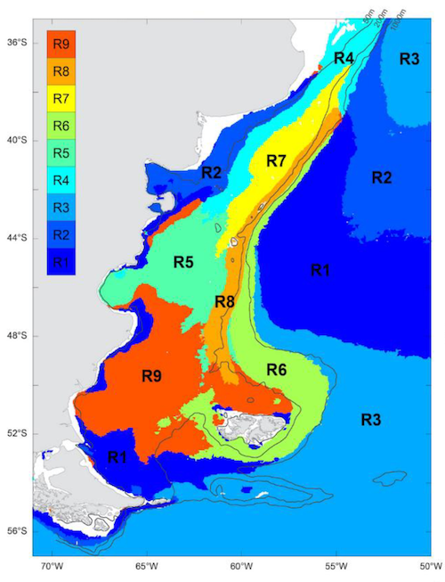
Abstract:The Southwestern Atlantic Ocean (SWA), is considered one of the most productive areas of the world, with a high abundance of ecologically and economically important fish species. Yet, the biological responses of this complex region to climate variability are still uncertain. Here, using 24 years of satellite-derived Chl-a data, we classified the SWA into 9 spatially coherent regions based on the temporal variability of Chl-a concentration, as revealed by SOM (Self-Organizing Maps) analysis. These biogeographical regions were the basis of a regional trend analysis in phytoplankton biomass, phenological indices, and environmental forcing variations. A general positive trend in phytoplankton concentration was observed, especially in the highly productive areas of the northern shelf-break, where phytoplankton biomass has increased at a rate of up to 0.42 ± 0.04 mg m−3 per decade. Significant positive trends in sea surface temperature were observed in 4 of the 9 regions (0.08–0.26 °C decade−1) and shoaling of the mixing layer depth in 5 of the 9 regions (−1.50 to −3.36 m decade−1). In addition to the generally positive trend in Chl-a, the most conspicuous change in the phytoplankton temporal patterns in the SWA is a delay in the autumn bloom (between 15 ± 3 and 24 ± 6 days decade−1, depending on the region). The observed variations in phytoplankton phenology could be attributed to climate-induced ocean warming and extended stratification period. Our results provided further evidence of the impact of climate change on these highly productive waters.
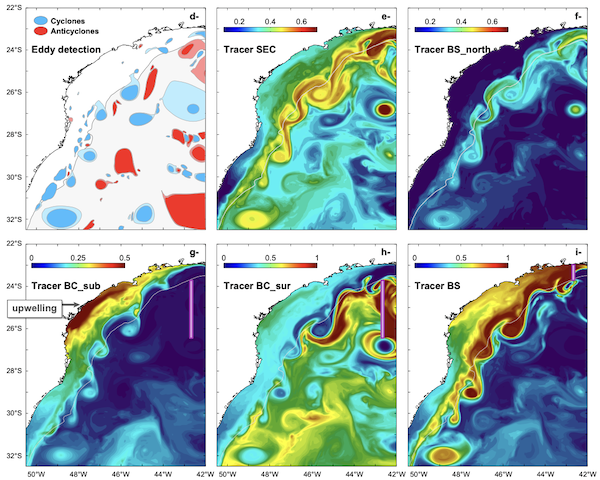
Abstract:The strong interaction between the Brazil Current and the adjacent shelf is clearly visible in satellite-derived products (sea surface temperature, salinity, and chlorophyll-a concentration). Assessments of circulation features and cross-shelf exchanges from these products are, however, limited to the surface layer. Here we analyze the regional circulation and dynamics using the results of a suite of process-oriented, high-resolution numerical experiments. Passive tracers and Lagrangian floats characterize the exchanges between the shelf and the open ocean, identifying regions of high variability, and assessing the contribution of small-scale eddies to the cross-shelf mass exchanges. We estimate that 0.2-0.4Sv of the shelf transport variability between 34°S and 25°S comes from ocean internal variability which represents ~50%-70% of the total variability. Between 25°S and 21°S, internal ocean variability represents more than 90% of the shelf transport variability. We find that generation of cyclonic eddies is more frequent (>15% of the time) at the shelfbreak bights. The core of these eddies contains fresher, colder, and more nutrient-rich shelf waters. Maps of satellite chlorophyll-a concentration suggest that the horizontal and vertical exchanges of mass associated with these eddies are a critical element of the primary production cycle.
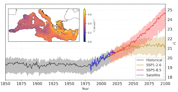
Abstract:The study of marine heat waves as extreme temperature events has a wide range of applications, from a gauge for ecological and socioeconomic impact to a climate change indicator. Various definitions of marine heat waves as extreme sea temperature events exist to account for its broad applicability, with statistical definitions based on percentile based thresholds being widespread in its use. Using satellite and model data of the Mediterranean Sea, we analyze the statistical implications of choosing baseline climatological periods for threshold delineation, which are either fixed in the past or shifted in time. We show that in the context of a warming Mediterranean Sea, using a fixed baseline leads to a saturation of marine heat wave days that compromises the significance of this marine indicator, with 90% of climate models analyzed predicting an average above 189 marine heat wave days per year by 2050 even for the lowest emission scenario. We argue that only with a moving baseline, can we reach a definition for marine heat waves which yield consistently rare extreme events.
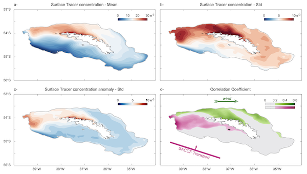
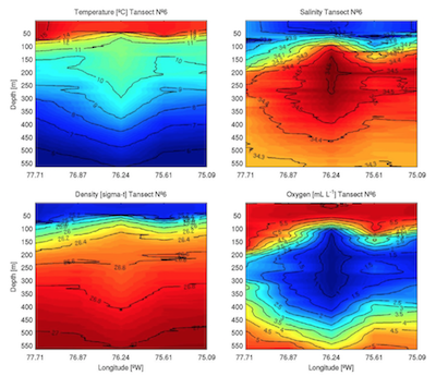
Abstract: A high-resolution ocean model is used to characterize the variability of the shelf circulation and cross-shelf transport around the South Georgia island (SG). The time-mean shelf circulation consists of a counterclockwise flow with a net onshelf mass flow in the south and a net offshelf mass flow in the north. In the south, the cross-shelf exchanges show a two-layer structure with an offshelf flow below 350m and onshelf flow above. In the north, the cross-shelf exchanges show a three-layer structure with the onshelf flow found only between 350m-50m. Correlation analysis shows that winds and the Southern Antarctic Circumpolar Current Front (SACCF) current modulate the variability of the shelf circulation and cross-shelf transport. Local wind stress is significantly correlated with the coastal currents, mid-shelf jet, and cross-shelf transports in the upper layer, while the SACCF modulates the shelf and cross-shelf transports in the southwestern shelf. Likewise, an Empirical Orthogonal Function analysis indicates that the first mode of shelf circulation variability is highly correlated with the SACCF, while the second mode is explained by the local wind stress and significantly correlated with the Antarctic Oscillation. The El Niño Southern Oscillation does not significantly contribute to the shelf circulation but is significantly correlated with the surface temperature variability. The atmospheric teleconnection drives changes in local heat flux, such that warm El Niño conditions over the equatorial Pacific are associated with a cooling of the SG waters. This superposes local signals onto temperature anomalies advected from upstream in the ACC found in previous studies.
2022
Abstract: The yellow clam Mesodesma mactroides is a cool-water species that typifies sandy beaches of the Southwestern Atlantic Ocean (SAO), which embraces one of the strongest ocean warming hotspots. The region is influenced by the Rio de la Plata (RdlP), which represents a zoogeographic barrier that restricts its larval exchange. We investigated yellow clam larval connectivity patterns using an individual based model (IBM). The IBM combined outputs from a 3D hydrodynamic model with a clam submodel that considered salinity- and temperature-dependent mortality for the planktonic larvae. Connectivity across the RdlP estuary occurred only for larvae released in spring during a strong La Niña event. Mortality due to freshwater precluded larval transport across the RdlP, whereas larval mortality induced by warmer waters reduced connectivity, leading to self-recruitment in most areas. Warming acceleration in this hotspot could further restrict larval connectivity between populations in the SAO, with conservation implications for this threatened species.
2021
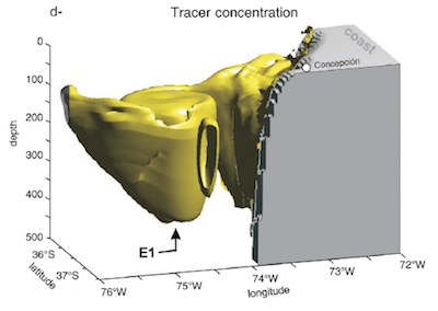
Abstract: The Malvinas Islands shelf (MIS) encompasses one of the most productive portions of the southwestern Atlantic. Large phytoplankton blooms, which constitute the base of the marine food web, emerge from the northern sector of the MIS and extend hundreds of kilometers northward along the Patagonian shelfbreak. The physical processes contributing to MIS fertilization are poorly understood. Here we use the results of a high-resolution ocean model to characterize circulation and water mass exchanges between the MIS and the Southern Ocean, as well as to identify the physical processes underlying fertilization of the shelf waters. Model results show that the shelf is characterized by an anticyclonic circulation pattern in the southwestern region that intensifies during summer and weakens during winter. The blocking effect of the islands leads to development of an upwind westward-flowing current in the northern portion of the MIS, recirculation cells in the western portion, and a northward throughflow in the narrow strait separating them. Particle tracking experiments reveal that the northern portion of the Drake Passage is the largest water mass source for the MIS. Passive tracers indicate that the place where the Antarctic Circumpolar Current collides with the MIS is the main shelfbreak obduction region. Subsequent development of tracer obduction is largely driven by the synergetic interaction of tides and wind forcing. After spreading along the southwestern shelfbreak, the concentration of tracer peaks in the winter and decays during the spring. In summer, the tracer accumulates on the lee of the islands in agreement with satellite images of chlorophyll-a concentration. Additional experiments show that there is an important contribution of MIS waters to the Patagonian shelfbreak front.
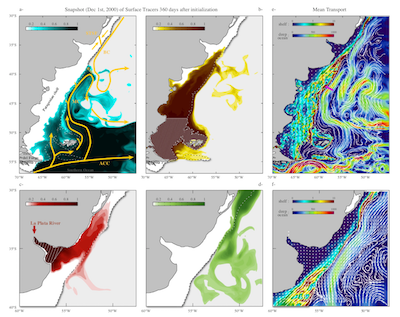
Abstract: A high-resolution ocean model is used to characterize the circulation and cross-shelf exchanges in the Brazilian/Uruguayan portion of the southwestern Atlantic shelf. Cross-shelf exchanges are strongly modulated by the bottom topography. There is ∼1.2 Sv of on-shelf transport between 21°S and 25.2°S, and ∼1.6 Sv of off-shelf transport between 35°S and 25.2°S. North of 25.2°S, the cross-shelf exchanges show a two-layer structure with an off-shelf flow in the upper 50m and on-shelf flow deep below. A Lagrangian diagnostic shows that ∼0.15 Sv of deep waters from the Brazil Current (z > 200 m) are injected into the shelf. Mixing with ambient waters produces a spicier (warmer and saltier) water mass, which is ejected into the open ocean in the southern region. Backward in-time particle's trajectories analysis reveals that 95% of the southward shelf transport at 32°S originates in the open ocean at 22°S. Our model diagnostics show that there is a very limited connectivity between the shelf regions north and south of Cabo Frio. Correlation analysis shows no significant influence of El Niño Southern Oscillation (ENSO) and Southern Annular Mode (SAM) on the time variability of the cross-shelf transport. Cross-shelf transports, however, are significantly correlated with the local wind stress variability.
2020
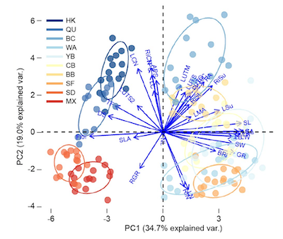
Abstract: Aim: Studies on latitudinal patterns in plant defence have traditionally overlooked the potential effect that resource availability may have in shaping plant defence. Likewise, latitudinal patterns of tolerance traits have rarely been studied, yet they can be a critical component of plant defence. Therefore, the aim of our study was to examine latitudinal variation in the production of tolerance and resistance traits against her- bivory along a latitudinal range and a natural gradient of resource availability from upwelling conditions. Location: Canada, North America and Mexico. Time period: Summer months of 2015. Major taxa used: The seagrass Zostera marina. Methods: We conducted experiments simulating macroherbivore (e.g., bird, fish) dam- age on the seagrass Z. marina at 10 sites across the Eastern Pacific coast (Canada– Mexico) and Quebec and analysed several traits related to resistance and tolerance strategies against herbivory. In addition, we examined the effects of potential sea- grass changes in defence strategies by performing a series of feeding experiments with mesoherbivores in a subset of sites. Results: We found that eelgrass resistance defences did not follow a linear latitudinal pattern but rather followed a bell-shaped curve which correlated with bottom-up control. In sites with higher nutrient availability, plants allocated resources to tol- erance strategies and had lower resistance traits. Furthermore, seagrasses did not respond linearly to increased herbivory pressure; while they tolerated moderate lev- els of herbivory, they underwent a significant reduction in tolerance and resistance under high herbivory levels, which also made them more susceptible to consumers in feeding experiments. Main conclusions: Our results highlight the importance that nutrient availability has in shaping latitudinal patterns of plant defence against herbivory and show how these defences may not respond linearly to increased herbivory pressure in seagrasses.
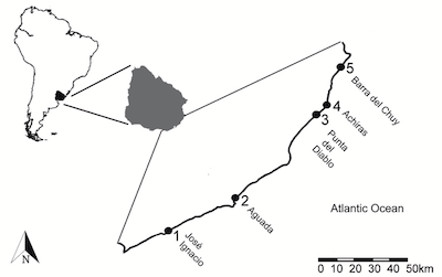
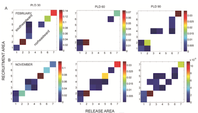
Abstract: The biophysical mechanisms influencing larval distribution and their impacts on the metapopulation dynamics of sandy beaches, particularly the connectivity patterns associated with larval dispersal, are poorly understood. Here, we identify larval connectivity patterns of the mole crab Emerita brasiliensis in the coast of Uruguay. A biophysical individual based model (IBM) of larval transport was coupled to a regional high-resolution physical model to estimate the monthly and interannual variation of larval connectivity, as well as the impact of the length of the reproductive period on it. Larval connectivity showed marked interannual variations, which were mainly related to interannual changes in seasonal winds and associated ocean circulation patterns, particularly during La Niña years. The southernmost area where E. brasiliensis occurs only received larvae from the nearest release area in November and January spawning events during a strong La Niña year, characterized by intense northeasterly winds. The Uruguayan coast constitutes the leading (poleward) edge of the distribution of E. brasiliensis, where climate change effects are projected to intensify. Extrapolation of these results to a climate change scenario with stronger La Niña events, suggest that larval transport to southernmost beaches will become more probable.
Abstract: In the southwest South Atlantic Ocean (SWAO) strong ocean surface warming hotspots have been observed mainly along the path of the Brazil Current (BC), Brazil-Malvinas Confluence (BMC), and in the Río de la Plata (RdlP). However, there is no knowledge about the signature of ocean hotspots below the surface and the potential effects of ocean warming on marine biota. In this work, we provide initial evidence of how deep the hotspots of the SWAO extend in the water column, in particular at mid-water and bottom layers where two marine species - the green turtle (Chelonia mydas) and the Patagonian scallop (Zygochlamys patagonica) - inhabit. We compare 15 years (2003–2017) of Copernicus Marine Environment Monitoring Service (CMEMS) ARMOR3D high−resolution (1/4◦) 3-D temperatures reprocessed from combined satellite and in situ observations with high−resolution (1/12◦) Mercator ocean reanalysis. We also use location data of C. mydas and Z. patagonica to discuss the potential impacts of warming on these species in terms of geographic distribution, phenological shifts and thermal tolerance. The potential distribution of C. mydas changes in relation to the sea surface temperature (SST) and the bathymetry. The warming of the whole water column in the RdlP (>0.4◦C/decade) and the southward movement of the mean surface isotherms, which likely drove turtle displacements, could enable the opening up of novel optimal thermal habitats and/or a longer seasonal residency for the species. At the BMC, warming is driven by the southward displacement of the BC during the past decades. Ocean model temperature indicates cooling/warming in deep waters along the outer shelf and shelf break regions, which vary according the displacements of the BMC. The expected warming of the waters over the Patagonian scallop largest bed could exceed the thermal tolerance of this species and its survival. Given the lack of long-term monitoring programs to address the impacts of climate change on marine biota in the SWAO, our results provide the first effort to call the attention of stakeholders and decision makers on marine conservation and fishery management to work toward better management strategies in the context of climate change.
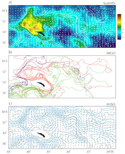
Abstract:The northeast corner of the Scotia Sea hosts one of the largest chlorophyll-a blooms of the Southern Ocean. This bloom peaks to the northwest of the island of South Georgia, extending eastward for hundreds of kilometers. Although the Southern Ocean has many islands of similar size, South Georgia is ecologically one of the most significant: it not only sustains one of the Southern Ocean’s largest and most diverse ecosystems but also is its single most important region for biological carbon sequestration. While the exceptional nature of South Georgia’s blooms has been widely recognized, both the physical processes that contribute to their fertilization and the reasons why these blooms are larger than those of other similar regions (e.g. Kerguelen or Crozet Islands), are poorly understood. We use the results of a high-resolution ocean model to investigate the physical processes that mediate the entrainment of deep, iron rich waters into the surface layers of the South Georgia region. We show that the Southern Antarctic Circumpolar Current Front, the southernmost jet of the Antarctic Circumpolar Current (ACC), pumps iron-enriched waters from the deep ocean onto the bottom layers of South Georgia’s shelf. These waters are upwelled along the northern coast of the island and are then exported into the Georgia Basin, where topographically steered circulation shields them from the dispersive effects of local currents and eddies, thus allowing the bloom development.
Abstract:This study identifies the dynamical mechanisms driving seasonal variations in oceanic circulation and water mass characteristics of the Gulf of San Jorge (GSJ) and its exchanges with the Patagonian Shelf (PS). A suite of process-oriented numerical experiments indicates that GSJ circulation is mainly driven by tidal forcing and modulated by wind forcing and intrusions from the PS. During late spring and summer, stratification decouples the upper and deeper layers of the gulf, leading to a shallow, wind-forced surface circulation and a deeper, density driven, cyclonic geostrophic flow. The subsurface circulation is induced by differential tidal mixing in coastal and deep areas and its intensity is strongly affected by the temporal variability of the atmospheric heat flux, which increases from spring to summer and fades from fall to winter. As stratification weakens, circulation patterns are replaced by wind-driven anticyclonic gyres in the south and an open cyclonic loop in the north. Passive tracer diagnostics show that in summer, surface and subsurface waters from the GSJ northern coast are exported and replaced by waters from the coastal portion of PS currents. The renewal of bottom waters is slower: A small portion upwells in the southwestern coast but most are ventilated by winter convection in the southern region and by intrusions of PS waters in the northern region
2019
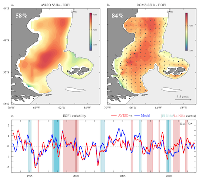
Abstract: In this study, we identify the drivers of the dominant mode of sea surface height interannual variability over the Patagonian shelf using a suite of process-oriented numerical experiments. Consistent with altimetry, the dominant mode of the model sea surface height interannual variability, which accounts for approximately 84% of the total variance, exhibits a robust deterministic low-frequency variability. The weak sea surface height gradients indicate that this mode has a weak dynamical effect, but the contribution of the steric effect is shown to be non significant. Here we demonstrate that the temporal variability of this mode is not driven by heat or freshwater fluxes but by the propagation of sea surface height perturbations generated in the Pacific. In particular, we show that sea surface height interannual variability over the Patagonian shelf is influenced by wind stress forcing in the offshore region of southern Chile and by the propagation of equatorial sea surface height anomalies.
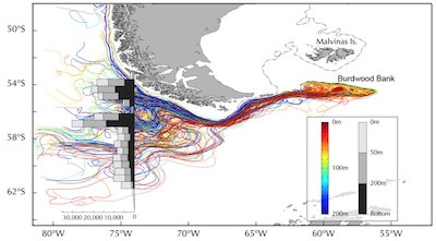
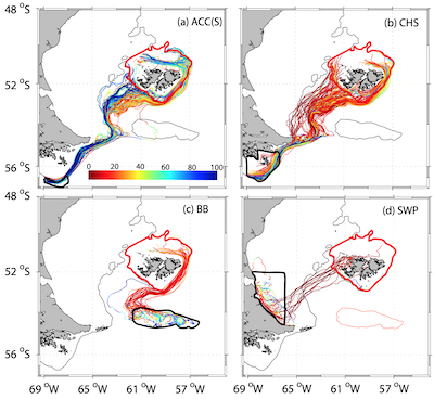
Abstract: A suite of high‐resolution numerical simulations characterizes the oceanic circulation in the Burdwood Bank (BB), a shallow seamount located in the northeastern end of the Drake Passage. Model analysis shows energetic upwelling and mixing uplifting deep and benthic waters into the photic layer. Tides and the Antarctic Circumpolar Current are the primary drivers of the bank's circulation. Tidal forcing is the main driver for the entrainment of deep waters into the upper layers of the bank and local wind forcing for the detrainment of these waters into the deep ocean. Passive tracer diagnostics suggest that the dynamical processes triggered by the BB could have a significant impact on local ecosystems and the biogeochemical balance of the southwestern Atlantic region, which is one of the most fertile portions of the Southern Ocean. Model results are robust—they are reproduced in a wide array of model configurations—but there is insufficient observational evidence to corroborate them. Satellite color imagery does not show substantial chlorophyll blooms in this region but it shows strong phytoplankton plumes emanating from the bank. There are several potential explanations for the chlorophyll deficit, including lack of light due to persistent cloud cover, deep mixing layers, fast ocean currents and the likelihood that blooms, while extant, might not develop on the surface. None of these possibilities can be confirmed at this stage.
2018
Abstract: A high-resolution ocean model is used to characterize the local and remote driving mechanisms of the variability of the Patagonian shelf circulation. Local forcing includes the effects of tides, buoyancy fluxes and wind, while remote forcing represents the impact of the adjacent deep-ocean currents. There is an abrupt change of the dynamical characteristics of the shelf circulation at 40°S. South of 40°S, the seasonal variations of the shelf circulation are out of phase with the local wind stress and are driven by deep ocean inflows originated in the Drake Passage. The inter-annual variability of the shelf circulation is principally driven by the wind and shows a significant correlation with the time variations of the Southern Annular Mode index. The variability of the circulation and upwelling at the shelfbreak region are modulated by the variability of the Malvinas Current transport at low frequency (periods higher than two years), and by the local wind stress at higher frequencies. North of 40°S, the local wind forcing drives the seasonal variations of the shelf transport. The inter-annual variability of the flow is driven by the combined action of the Rio de la Plata discharge (significantly correlated with the El Niño Southern Oscillation), local wind stress and the Brazil-Malvinas Confluence in the outer shelf. In agreement with previous studies, we show that while the position of the confluence marks the location of the largest offshelf transports, it does not determine their magnitude. The offshelf transport variability is controlled by the local wind at high frequency (periods less than a year) and by the equatorward inflow of southern waters at longer periods. Our simulation indicates that the variability of the Subtropical Shelf Front is modulated by the local wind stress forcing, position of the Brazil/Malvinas Confluence and the equatorward inflow of Subantarctic waters.
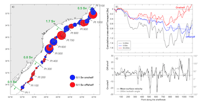
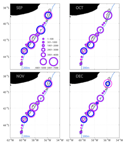
Abstract: It has been suggested that the Subtropical Shelf Front (STSF) could be a preferential site for the detrainment of Subantarctic Shelf Waters (SASW) and related planktonic shelf species onto the open SW Atlantic Ocean. The offshore detrainment of SASW and planktonic shelf species might be an exportation mechanism, affecting the population abundances of fishing resources in Argentina, Uruguay and Southern Brazil. In this study, we characterize for the first time the 3-D structure of the STSF and the main routes of offshore export of SASW from the Patagonian shelf during austral summer (summer and early fall) and winter (winter and early spring) by using numerical hydrodynamical model results and Lagrangian tracking simulations of neutrally buoyant floats. The transport of SASW towards the open ocean is 1 Sv (1 Sv = 106 m3.s-1) during summer and 0.8 Sv during winter. SASW are exported offshore mainly near the Brazil–Malvinas Confluence (BMC) region during both seasons. The STSF appears to act as an important retention mechanism for the plankton over the inner and middle shelf mainly during late summer and early fall. Our findings could explain the life cycle of distinct fish species which are distributed in the region, as well as the population abundance variability of such species.
Abstract: The California Current System (CCS) is an eastern boundary upwelling system characterized by strong eddies that are often generated at the coast. These eddies contribute to intense, long-distance cross-shelf transport of upwelled water with enhanced biological activity. However, the mechanisms of formation of such coastal eddies, and more importantly their capacity to trap and transport tracers, are poorly understood. Their unpredictability and strong dynamics leave us with an incomplete picture of the physical and biological processes at work, their effects on coastal export, lateral water exchange among eddies and their surrounding waters, and how long and how far these eddies remain coherent structures. Focusing our analysis on the southern part of the CCS, we find a predominance of cyclonic eddies, with a 25-km radius and a SSH amplitude of 6 cm. They are formed near shore and travel slightly northwest offshore for ~190 days at ~2 km day−1. We then study one particular, representative cyclonic eddy using a combined Lagrangian and Eulerian numerical approach to characterize its kinematics. Formed near shore, this eddy trapped a core made up of ~67% California Current waters and ~33% California Undercurrent waters. This core was surrounded by other waters while the eddy detached from the coast, leaving the oldest waters at the eddy’s core and the younger waters toward the edge. The eddy traveled several months as a coherent structure, with only limited lateral exchange within the eddy.
2017
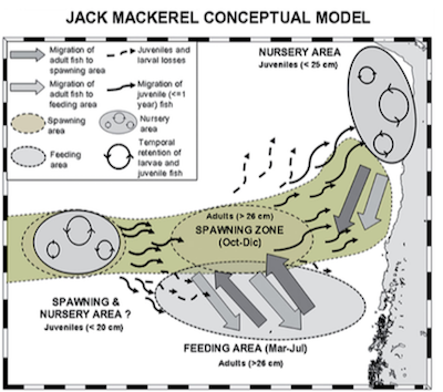
Abstract: Juvenile jack mackerel were found in 2009 in the Challenger break and the East Pacific ridge (CHAEPR). This seamount region is ∼3500 km from the coastal historic jack mackerel nursery grounds off Chile (north of 30°S). We reviewed historic evidence of juveniles around this seamount and data on several local environmental conditions: sea surface temperature, chlorophyll-a, wind, turbulence levels, and Eddy kinetic energy (EKE). A Lagrangian model for the early life stages of jack mackerel in the eastern South Pacific was used to assess the potential of the seamount region as a permanent nursery ground. Transport/retention mechanisms were assessed by releasing virtual particles coupled to a growth model into the flow simulated by an eddy-resolving ocean model. Model simulations showed high inter-annual variability for particle retention in the seamount region; high retention levels were associated with low EKE such that the particles were retained for several months. Satellite altimetry has shown a local minimum in eddy activity in the region where the juveniles were observed; this minimum was consistent with the above temporal relationship. The inclusion of the CHAEPR oceanic seamount region as a potential nursery ground for jack mackerel expands the current conceptual framework for the spatial population structure of this species in the South Pacific off central Chile proposed by Arcos et al. (The jack mackerel fishery and El Niño 1997–98 effects off Chile. Progress in Oceanography 49: 597–617, 2001). Finally, we discuss the relevance of seamounts playing a double role (spawning and nursery grounds) from the standpoint of conservation and biodiversity.
Abstract: The largest beds of the Patagonian scallop (Zygochlamys patagonica) have been associated with high chlorophyll- a concentration observed along the Patagonian Shelf Break Front but there is no supported hypothesis about how this benthic-pelagic connection is maintained. In this work we address the main physical processes driving the benthic-pelagic linkages through oriented numerical experiments derived from a realistic, high-resolution numerical model, and Lagrangian stochastic simulations. The results support the hypothesis of an important dynamical control of the slope current on the fate of surface released passive particles and their subsequent bottom settlement. A high percentage of the particles released at the surface settled over the scallop beds. The particles remaining at the surface layer followed a prevailing NE flow direction with low cross-shelf dispersion. Additional experiments show that the secondary cross-shelf circulation forced by the slope current promotes downwelling and hence the settlement of particles on the westward side (onshore) of the shelf break. The percent of particles settling over the scallop beds exceeded 80% by the addition of vertical stochastic turbulence and tidal forcing. These results highlight the importance of including the vertical diffusivity in particle tracking experiments to better estimate benthic-pelagic interaction processes.
2016
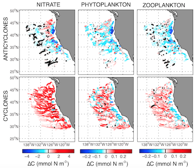
Abstract: The California Current System (CCS) has intense mesoscale activity that modulates and exports biological production from the coastal upwelling system. To characterize and quantify the ability of mesoscale eddies to affect the local and regional planktonic ecosystem of the CCS, we analyzed a 10 year-long physical-biological model simulation, using eddy detection and tracking to isolate the dynamics of cyclonic and anticyclonic eddies. As they propagate westward across the shelf, cyclonic eddies efficiently transport coastal planktonic organisms and maintain locally elevated production for up to 1 year (800 km offshore). Anticyclonic eddies, on the other hand, have a limited impact on local production over their ~6 month lifetime as they propagate 400 km offshore. At any given time ~8% of the model domain was covered by eddy cores. Though the eddies cover a small area, they explain ~50 and 20% of the transport of nitrate and plankton, respectively.
2015
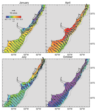
Abstract: Altimeter sea surface height (SSH) fields are analyzed to define and discuss the seasonal circulation over the wide continental shelf in the SW Atlantic Ocean (278–438S) during 2001–2012. Seasonal variability is low south of the Rio de la Plata (RdlP), where winds and currents remain equatorward for most of the year. Winds and currents in the central and northern parts of our domain are also equatorward during autumn and winter but reverse to become poleward during spring and summer. Transports of shelf water to the deep ocean are strongest during summer offshore and to the southeast of the RdlP. Details of the flow are discussed using mean monthly seasonal cycles of winds, heights, and currents, along with analyses of Empirical Orthogonal Functions. Principle Estimator Patterns bring out the patterns of wind forcing and ocean response. The largest part of the seasonal variability in SSH signals is due to changes in the wind forcing (described above) and changes in the strong boundary currents that flow along the eastern boundary of the shelf. The rest of the variability contains a smaller component due to heating and expansion of the water column, concentrated in the southern part of the region next to the coast. Our results compare well to previous studies using in situ data and to results from realistic numerical models of the regional circulation.
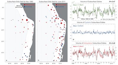
Abstract: The Southeast Pacific, which encompasses the coasts of Peru and Chile, is one of the world’s most productive regions resulting principally from the upwelling of subsurface nutrient-rich waters. Over the satellite altimetry era, there have been numerous evidence that surface mesoscale eddies play an important role in the offshore transport of rich coastal waters, but it has been only recently that few observational/numerical studies have highlighted the importance of the subsurface eddies. The eddy field variability is explored using the results of a high-resolution model experiment from 1979 to 2012. The model results indicate an asymmetry of the surface and subsurface eddy fields. While surface-intensified cyclones are slightly more frequent than anticyclones, the subsurface field is dominated by anticyclones (IntrathermoclineEddies; ITEs), triggered by the instability of the subsurface Peru Chile undercurrent (PCUC). Composite maps are consistent with in situ observations. ITEs are associated with maximum vorticity around 150–200 m depth, warmer and more saline core, characteristic of the equatorial subsurface water from the PCUC. We find that the variability of the ITEs is significantly correlated with the ENSO equatorial signal. During strong El Nino events (e.g., 1982; 1998), we find that while the PCUC transport increases, the volume of coastal waters transported by ITEs however decreases during those periods. We find that the relaxation of the isopycnals along the coast during El Nino events leads to weakened baroclinic instability and to a decrease of the ITEs transport. .
2014
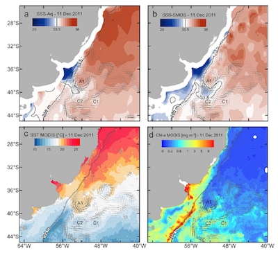
Abstract: Satellite-derived sea surface salinity (SSS) data from Aquarius and SMOS are used to study the shelf-open ocean exchanges in the western South Atlantic near 35 S. Away from the tropics, these exchanges cause the largest SSS variability throughout the South Atlantic. The data reveal a well-defined seasonal pattern of SSS during the analyzed period and of the location of the export of low-salinity shelf waters. In spring and summer, low-salinity waters over the shelf expand offshore and are transferred to the open ocean primarily southeast of the river mouth (from 36 S to 37 300S). In contrast, in fall and winter, low-salinity waters extend along a coastal plume and the export path to the open ocean distributes along the offshore edge of the plume. The strong seasonal SSS pattern is modulated by the seasonality of the along-shelf component of the wind stress over the shelf. However, the combined analysis of SSS, satellite-derived sea surface elevation and surface velocity data suggest that the precise location of the export of shelf waters depends on offshore circulation patterns, such as the location of the Brazil Malvinas Confluence and mesoscale eddies and meanders of the Brazil Current. The satellite data indicate that in summer, mixtures of low-salinity shelf waters are swiftly driven toward the ocean interior along the axis of the Brazil/Malvinas Confluence. In winter, episodic wind reversals force the low-salinity coastal plume offshore where they mix with tropical waters within the Brazil Current and create a warmer variety of low-salinity waters in the open ocean.
Abstract: A high-resolution model is used to characterize the dominant patterns of sea surface salinity (SSS) variability generated by the freshwater discharges of the Rio de la Plata (RdlP) and the Patos/Mirim Lagoon in the southwestern Atlantic region. We identify three dominant modes of SSS variability. The first two, which have been discussed in previous studies, represent the seasonal and the interannual variations of the freshwater plumes over the continental shelf. The third mode of SSS variability, which has not been discussed hitherto, represents the salinity exchanges between the shelf and the deep ocean. A diagnostic study using floats and passive tracers identifies the pathways taken by the freshwater plumes. During the austral winter (JJA), the plumes leave the shelf region north of the BMC. During the austral summer (DJF), the plumes are entrained more directly into the BMC. A sensitivity study indicates that the high-frequency component of the wind stress forcing controls the vertical structure of the plumes while the low-frequency component of the wind stress forcing and the interannual variations of the RdlP discharge controls the horizontal structure of the plumes. Dynamical analysis reveals that the cross-shelf flow has a dominant barotropic structure and, therefore, the SSS anomalies detected by Aquarius represent net mass exchanges between the shelf and the deep ocean. The net cross-shelf volume flux is 1.21 Sv. This outflow is largely compensated by an inflow from the Patagonian shelf
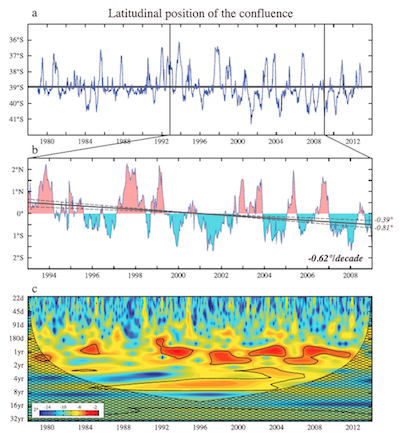
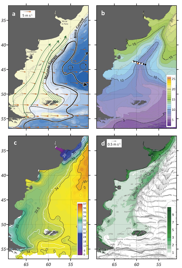
Abstract: Observations show abrupt changes in the oceanic circulation of the southwestern Atlantic. These studies report a southward drift of the Brazil/Malvinas Confluence (BMC) and a change in the spectral characteristics of the Malvinas Current (MC) transport. We address the cause of these changes using the result of a high-resolution numerical experiment. The experiment, which is consistent with observations, shows a southward BMC displacement at a rate of 0.62°/decade between 1993 and 2008, and a shift of the spectral characteristics of the MC transport after 1999. We find that these changes are driven by a weakening of the northern branch of the Antarctic Circumpolar Current, which translates to a weakening of the MC transport and a southward BMC drift. The drift changes the spectral characteristics of the MC transport, which becomes more influenced by annual and semiannual variations associated with the BMC.
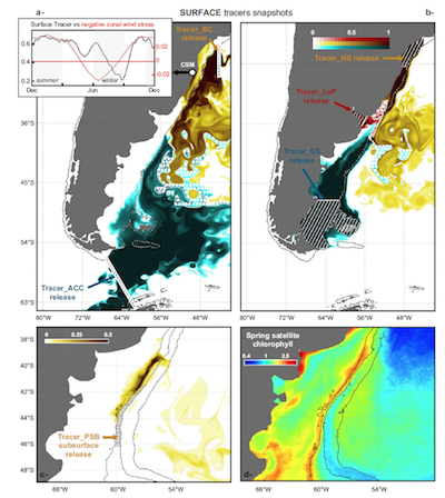
Abstract: This article presents the results of a high-resolution (1/12 ), two-way nested simulation of the oceanic circulation in the southwestern Atlantic region. A comparison between the model results and extant observations indicates that the nested model has skill in reproducing the best-known aspects of the regional circulation, e.g., the volume transport of the ACC, the latitudinal position of the BMC, the shelf break upwelling of Patagonia, and the Zapiola Anticyclone. Sensitivity experiments indicate that the bottom stress parameterization significantly impacts the mean location of the Brazil/Malvinas Confluence and the transport of the Zapiola Anticyclone. The transport of the Brazil Current strengthens during the austral summer and weakens during the austral winter. These variations are driven by the wind stress curl over the southwestern Atlantic. The variations of the transport of the Malvinas Current are out of phase with those of the Brazil Current. Most of the seasonal variability of this current is concentrated in the offshore portion of the jet, the inshore portion has a weak seasonality that modulates the magnitude of the Patagonian shelf break upwelling. Using passive tracers we show that most of the entrainment of deep waters into the shelf occurs in the southernmost portion of the Patagonian shelf and along the inshore boundary of the Brazil Current. Shelf waters are preferentially detrained near the Brazil/Malvinas Confluence. Consistent with previous studies, our simulation also shows that south of 42 S the Malvinas Current is composed of two jets, which merge near 42 S to form a single jet farther north.
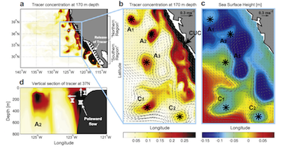
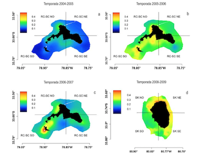
Abstract: Regional Ocean Modeling System (ROMS) results, combined with chlorophyll-a (Chl-a) and satellite altimetry information as well as information from oceanographic cruises were analyzed to identify interactions between intrathermocline eddies (ITEs) and the Juan Fernández Archipelago (JFA), and discuss their potential impact on surface Chl-a concentrations. The JFA is located off the coast of central Chile (33°S), and is composed of three main islands: Robinson Crusoe (RC), Alejandro Selkirk (AS) and Santa Clara (SC). Results indicate that the surface and subsurface anticyclonic eddies that interact with the JFA are formed primarily within the coastal transition zone between 33° and 39°S. ITEs are present within the JFA region with a semiannual frequency, mainly during the austral autumn, and have a weak surface expression in relation to the adjacent surface eddies, with a slow displacement (1.16 to 1.4 km d-1) in a northwest direction and a coherent structure for periods of ≥1 year. During the ITEs’ interaction with RC-SC islands and an adjacent seamount, a slight (prominent) thermocline deflection of the upper limit (lower) was observed. The horizontal extent (~70-100 km) was greater than the internal Rossby deformation radius and the average vertical extent was ~400 m. The interaction between the weak surface expression of ITEs, identified with satellite altimetry, and the JFA persisted during autumn for nine weeks until reaching the winter period. Approximately one month after the beginning of the interaction between ITEs and the islands, increases in surface Chl-a associated with the eddy were observed, with values up to three times higher than adjacent oceanic waters.
2013
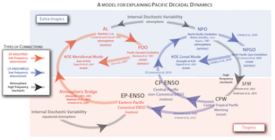
Abstract: The goal of the Pacific Ocean Boundary Ecosystem and Climate Study (POBEX) was to diagnose the large-scale climate controls on regional transport dynamics and lower trophic marine ecosystem variability in Pacific Ocean boundary systems. An international team of collaborators shared observational and eddy-resolving modeling data sets collected in the Northeast Pacific, including the Gulf of Alaska (GOA) and the California Current System (CCS), the Humboldt or Peru-Chile Current System (PCCS), and the Kuroshio-Oyashio Extension (KOE) region. POBEX investigators found that a dominant fraction of decadal variability in basin and regional-scale salinity, nutrients, chlorophyll, and zooplankton taxa is explained by a newly discovered pattern of ocean-climate variability dubbed the North Pacific Gyre Oscillation (NPGO) and the Pacific Decadal Oscillation (PDO). NPGO dynamics are driven by atmospheric variability in the North Paci c and capture the decadal expression of Central Paci c El Niños in the extratropics, much as the PDO captures the low-frequency expression of eastern Paci c El Niños. By combining hindcasts of eddy-resolving ocean models over the period 1950–2008 with model passive tracers and long-term observations (e.g., CalCOFI, Line-P, Newport Hydrographic Line, Odate Collection), POBEX showed that the PDO and the NPGO combine to control low-frequency upwelling and alongshore transport dynamics in the North Pacific sector, while the eastern Pacific El Niño dominates in the South Pacific. Although different climate modes have di erent regional expressions, changes in vertical transport (e.g., upwelling) were found to explain the dominant nutrient and phytoplankton variability in the CCS, GOA, and PCCS, while changes in alongshore transport forced much of the observed long-term change in zooplankton species composition in the KOE as well as in the northern and southern CCS. In contrast, cross-shelf transport dynamics were linked to mesoscale eddy activity, driven by regional-scale dynamics that are largely decoupled from variations associated with the large-scale climate modes. Preliminary findings suggest that mesoscale eddies play a key role in o shore transport of zooplankton and impact the life cycles of higher trophic levels (e.g., fish) in the CCS, PCCS, and GOA. Looking forward, POBEX results may guide the development of new modeling and observational strategies to establish mechanistic links among climate forcing, mesoscale circulation, and marine population dynamics.
Abstract: The three-dimensional structure and the origin of mesoscale anticyclonic intrathermocline eddies (ITEs) in the coastal transition zone (CTZ) off central Chile (31– 41 S) were analyzed through the combination of data from oceanographic cruises and satellite altimetry, and the application of an eddy-resolving primitive equation ocean model coupled with a numerical experiment using a passive tracer. In this region, ITEs are represented by subsurface lenses ( 100 km diameter; 500 m thickness or vertical extension) of nearly homogeneous salinity (>34.5) and oxygen-deficient (1.0 mL L 1) waters, properties which are linked to the equatorial subsurface water mass (ESSW) transported poleward by the Peru-Chile undercurrent (PCUC) in the coastal band. At least five to seven ITEs were observed simultaneously in the area between 31 and 38 S during winter cruises in 1997 and 2009. Satellite data indicated that the ITEs identified from in situ data moved westward, each at a mean speed of 2 km d 1 and transported a total volume of 1 106 m3 s 1 (1⁄41 Sv); the lifespan of each ITE ranged from a few months to 1 year. Model results indicate that ITEs become detached from the PCUC under summer upwelling conditions in the coastal zone.
Abstract: The low-frequency dynamics of coastal upwelling and cross-shelf transport in the Central and Southern California Current System (CCS) are investigated using the Regional Ocean Modeling System (ROMS) over the period 1965–2008. An ensemble of passive tracers released in the numerical model is used to characterize the effects of linear (Ekman upwelling) and non-linear (mesoscale eddies) circulation dynamics on the statistics of advection of coastal waters. The statistics of passive tracers released in the subsurface show that the low-frequency variability of coastal upwelling and cross-shelf transport of the upwelled water mass are strongly correlated with the alongshore wind stress, and are coherent between the central and southern CCS. However, the offshore transport of tracers released at the surface is not coherent between the two regions, and is modulated by intrinsic mesoscale eddy activity, in particular cyclonic eddies. The transport of cyclonic eddies extends with depth and entrains water masses of southern origin, advected by the poleward California Undercurrent (CUC). The CUC water masses are not only entrained by eddies but also constitute a source for the central California upwelling system. The interplay between intrinsic (eddy activity) and deterministic (Ekman upwelling) dynamics in controlling the cross-shelf exchanges in the CCS may provide an improved framework to understand and interpret nutrients and ecosystem variability.
2012
Abstract: Located approximately 360 nm off the coast of Chile there is a disjoint realm of two small oceanic islands systems, the Juan Fernández and the Desventuradas archipelago. Currently the local economy of the islands is almost exclusively supported by the harvest and trade of marine resources, focusing mainly on the exploitation of the rock lobster (Jasus frontalis). This endemic species is distributed in both archipelagos, forming a metapopulation, whose population structure and dynamic is modulated by oceanographic forcing, especially during its extended planktonic larval phase. The population structure and the conection-retention within and between islands was assessed, based on the use of coupled biophysical model (the hidrodynamics model OFES and an individual-based model of J. frontalis). The analysis of the hydrodynamic model predictions showed the presence of mesoscale structures associated with the islands systems. The simulation results indicated significant levels of connectivity-retention within and between island systems showing also a strong interannual variation of these. Biophysical modeling results indicated that recruitment varibility associated with the Juan Fernández archipelago depends mainly on larvae originated within this system, which as well will contribute with recruits to the Desventuradas archipelago. The sensitivity analysis of the biophysical model to identify the potential biophysical forcing of the dependent variables of the model (e.g. connectivity-retention index), resulted in that temporal and spatial patterns reproductive larval stage duration and season (year) are highly significant factors. Finally, a metapopulation structure for J. frontalis, with a high level of connectivity in the archipelago of Juan Fernandez and a considerable amount of larvae in the Desventuradas islands is proposed. These fluxes are determined mainly by the coupling between prevailing biological and oceanographic factors.
2011
Abstract: In the Northern California Current (NCC), zooplankton communities show interannual and multiyear shifts in species dominance that are tracked by survival of salmon populations. These zooplankton community changes correlate with the Pacific Decadal Oscillation (PDO) index: a ‘warm-water’ copepod species group is more abundant during warm (positive) phases of the PDO and less abundant during cold (negative) phases; the reverse occurs for a ‘cold-water’ species group. The observed relationship led to the hypothesis that the relative dominance of warm/cold-water copepods in the NCC is driven by changes in the horizontal advection of surface water over different phases of the PDO. To test this hypothesis, variation in surface water advection to coastal regions of the NCC over the period of 1950–2008 was investigated using a Regional Ocean Modeling System (ROMS) and passive tracer experiments, then was compared with zooplankton collected off Oregon since 1996. Results showed that surface water advection varied with the phase of the PDO; the low-frequency component of advection anomalies strongly correlated with copepod species composition (R40.9). During positive phases of the PDO, current anomalies were northward and onshore, resulting in transport of warmer waters and the associated copepods into the region. During negatives phases, increased equatorward current anomalies led to a copepod community that was dominated by cold-water taxa. Our results support the hypothesis that climate-driven changes in basin-scale circulation controls copepod community composition in the NCC, and demonstrate that large-scale climate forcings downscale to influence local and regional ecosystem structure.
2009
Abstract: The marine ecosystem of the Gulf of Alaska (GOA) is one of the richest on the planet. The center of the GOA is characterized by high-nutrient and low-chlorophyll-a concentration. Recent observational studies suggest that advection of iron-rich coastal water is the primary mechanism controlling open ocean productivity. Specifically, there is evidence that mesoscale eddies along the coastal GOA entrain iron-rich coastal waters into the ocean interior. This study investigates the cross-shelf transport statistics in the GOA using a free-surface, hydrostatic, eddy-resolving primitive equation model over the period 1965–2004. The statistics of coastal water transport are computed using a model passive tracer, which is continuously released at the coast. The passive tracer can thus be considered a proxy for coastal biogeochemical quantities such as silicate, nitrate, iron, or oxygen, which are critical for explaining the GOA ecosystem dynamics. On average along the Alaska Current, it has been shown that at the surface while the advection of tracers by the average flow is directed toward the coast consistent with the dominant downwelling regime of the GOA, it is the mean eddy fluxes that contribute to offshore advection into the gyre interior. South of the Alaskan Peninsula, both the advection of tracers by the average flow and the mean eddy fluxes contribute to the mean offshore advection. On interannual and longer time scales, the offshore transport of the passive tracer in the Alaskan Stream does not correlate with large-scale atmospheric forcing, nor with local winds. In contrast in the Alaska Current region, stronger offshore transport of the passive tracer coincides with periods of stronger downwelling (in particular during positive phases of the Pacific decadal oscillation), which trigger the development of stronger eddies.
Abstract: An eddy-permitting ocean model of the northeast Pacific is used to examine the ocean adjustment to changing wind forcing in the Gulf of Alaska (GOA) at interannual-to-decadal timescales. It is found that the adjustment of the ocean model in the presence of mesoscale eddies is similar to that obtained with coarse-resolution models. Local Ekman pumping plays a key role in forcing pycnocline depth variability and, to a lesser degree, sea surface height (SSH) variability in the center of the Alaska gyre and in some areas of the eastern and northern GOA. Westward Rossby wave propagation is evident in the SSH field along some latitudes but is less noticeable in the pycnocline depth field. Differences between SSH and pycnocline depth are also found when considering their relationship with the local forcing and leading modes of climate variability in the northeast Pacific. In the central GOA pycnocline depth variations are more clearly related to changes in the local Ekman pumping than SSH. While SSH is marginally correlated with both Pacific Decadal Oscillation (PDO) and North Pacific Gyre Oscillation (NPGO) indices, the pycnocline depth evolution is primarily related to NPGO variability. The intensity of the mesoscale eddy field increases with increasing circulation strength. The eddy field is generally more energetic after the 1976–1977 climate regime shift, when the gyre circulation intensified. In the western basin, where eddies primarily originate from intrinsic instabilities of the flow, variations in eddy kinetic energy are statistically significant correlated with the PDO index, indicating that eddy statistics may be inferred, to some degree, from the characteristics of the large-scale flow.
2007
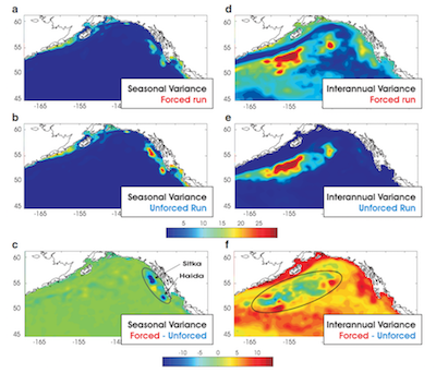
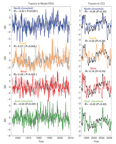
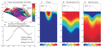
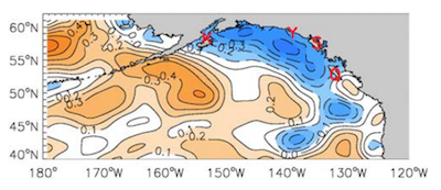
Abstract: The response of the Gulf of Alaska (GOA) circulation to large-scale North Pacific climate variability is explored using three high resolution (15 km) regional ocean model ensembles over the period 1950–2004. On interannual and decadal timescales the mean circulation is strongly modulated by changes in the large scale climate forcing associated with PDO and ENSO. Intensification of the model gyre scale circulation occurs after the 1976–1977 climate shift, as well as during 1965–1970 and 1993–1995. From the model dynamical budgets we find that when the GOA experiences stronger southeasterly winds, typical during the positive phase of the PDO and ENSO, there is net large-scale Ekman convergence in the central and eastern coastal boundary. The geostrophic adjustment to higher sea surface height (SSH) and lower isopycnals lead to stronger cyclonic gyre scale circulation. The opposite situation occurs during stronger northwesterly winds (negative phase of the PDO). Along the eastern side of the GOA basin, interannual changes in the surface winds also modulate the seasonal development of high amplitude anticyclonic eddies (e.g. Ha ̈ıda and Sitka eddies). Large interannual eddy events during winter-spring, are phase-locked with the seasonal cycle. The initial eddy dynamics are consistent with a quasi-linear Rossby wave response to positive SSH anomalies forced by stronger downwelling favorable winds (e.g. southwesterly during El Nin ̃o). However, because of the fast growth rate of baroclinic instability and the geographical focusing associated with the coastal geometry, most of the perturbation energy in the Rossby wave is locally trapped until converted into large scale nonlinear coherent eddies. Coastally trapped waves of tropical origin may also contribute to positive SSH anomalies that lead to higher amplitude eddies. However, their presence does not appear essential. The model ensembles, which do not include the effects of equatorial coastally trapped waves, capture the large Ha ̈ıda and Sitka eddy events observed during 1982 and 1997 and explain between 40% and 70% of the tidal gauges variance along the GOA coast. In the western side of the GOA basin, interannual eddy variability located south of the Alaskan Stream is not correlated with large scale forcing and appears to be intrinsic. A comparison of the three model ensembles forced by NCEP winds and a multi-century-long integration forced only with the seasonal cycle, shows that the internal variability alone explains most of the eddy variance. The asymmetry between the eddy forced regime in the eastern basin, and the intrinsic regime in the western basin, has important implications for predicting the GOA response to climate change. If future climate change results in stronger wintertime winds and increased downwelling in the eastern basin, then increased mesoscale activity (perhaps more or larger eddies) might occur in this region. Conversely, the changes in the western basin are not predictable based on environmental forcing. Eastern eddies transport important biogeochemical quantities such as iron, oxygen and chlorophyll-a into the gyre interior, therefore having potential upscale effects on the GOA high-nutrient-low-chlorophyll region.