 I am currently a Ramón y Cajal with double affiliation (IMEDEA / UIB, Mallorca, SPAIN) since summer 2022. Previously, I have been a Senior Research Associate at Oregon State University, in the CEOAS department since 2010.
I got my Phd from Georgia Tech (Atlanta) in 2010 and an engineering degree in Hydraulics from the ENSEEIHT (France) in 2005.
I am currently a Ramón y Cajal with double affiliation (IMEDEA / UIB, Mallorca, SPAIN) since summer 2022. Previously, I have been a Senior Research Associate at Oregon State University, in the CEOAS department since 2010.
I got my Phd from Georgia Tech (Atlanta) in 2010 and an engineering degree in Hydraulics from the ENSEEIHT (France) in 2005.

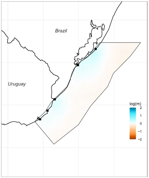
Abstract: Bio-oceanographic modeling and population genomics were combined to assess connectivity of the blue crab Callinectes sapidus in the Southwestern Atlantic Ocean, with particular attention to the scale of its fishery management, and the potential role of Marine Protected Areas (MPAs) in Uruguay as larval source zones. A bio-physical model, coupled with hydrodynamic outputs of a model experiment, incorporated larval vertical migration behavior and key species-specific traits to simulate dispersal pathways across the region. Population structure was assessed by using SNPs variability. Both approaches revealed substantial connectivity among sampled locations. Genomic population genetic analysis supported a single, well-mixed population across the study area, consistent with the extensive dispersal predicted by the model. These results highlight the need for management strategies tailored to the species' population structure and emphasize the importance of binational (Brazil-Uruguay) coordination for this transboundary fishery, which is already showing clear signs of overexploitation. Model simulations further showed that Uruguayan MPAs may act as important larval sources, particularly during winter recruitment under La Niña conditions, exporting propagules to non-protected areas in southern Brazil. By resolving the spatial and temporal scales of larval exchange, this study enhances regional understanding of connectivity patterns and supports evidence-based conservation planning for C. sapidus.
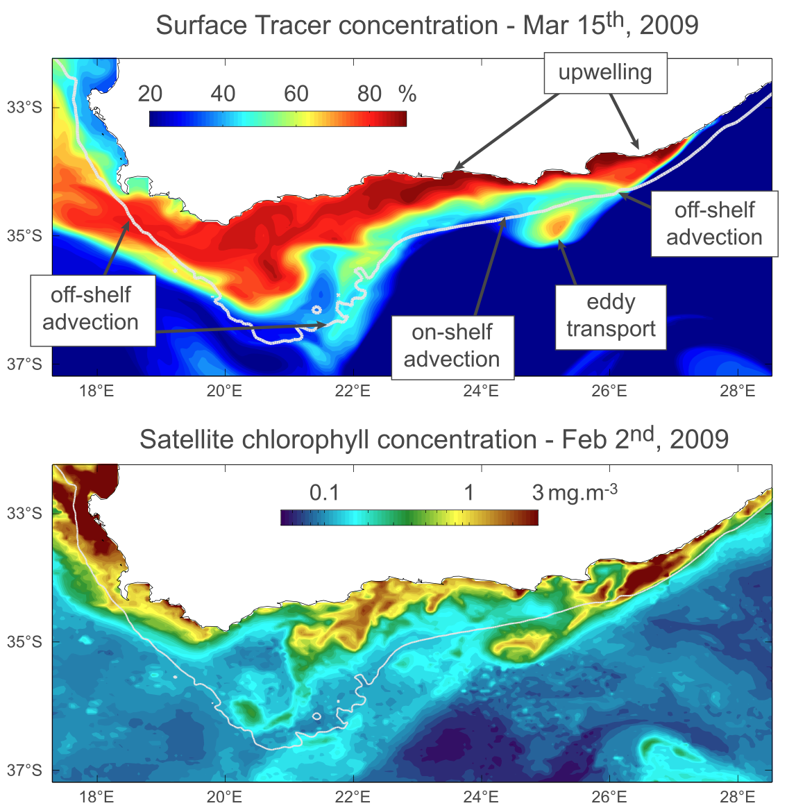
Abstract: This modeling study investigates the variability of the Agulhas Bank (AB) circulation, focusing on its connections to the local wind forcing and the Agulhas Current (AC) as well as to teleconnections to the tropical South Atlantic. The mean AB circulation is dominated by a westward flow composed of a coastal jet, an outer‐shelf flow influenced by AC intrusions, and a strong mid‐shelf jet shaped by both wind and AC dynamics. Empirical Orthogonal Function analyses of sea surface height (SSH) and temperature reveal patterns strongly linked to AC position and wind variability, with significant correlations between SSH anomalies and AC displacements. Passive tracer experiments show that while AC‐driven vertical transport can uplift deeper waters onto the shelf, wind‐driven upwelling and mixing are critical for surface expression. Tracer distribution is modulated by both wind and AC transport with contrasting spatial impacts. Furthermore, the study identifies a teleconnection with the tropical South Atlantic, as coastal trapped waves propagate interannual SSH variability southward, though their influence on AB circulation appears limited in dynamic significance. Overall, AB circulation emerges as a complex interplay of local and remote forcings, with variability largely governed by the AC and wind, and modulated by occasional tropical signals.
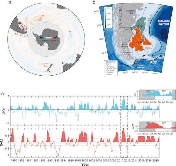
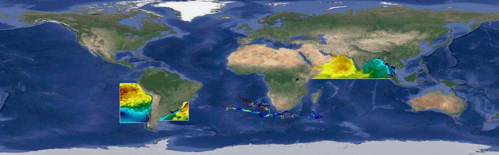
Abstract: Between mid-2010 and early 2012, the Southern Patagonian Continental Shelf (SPCS) experienced an exceptionally intense and persistent phytoplankton bloom, during which chlorophyll-a (Chl-a) concentrations doubled the climatological mean during the austral autumn and winter. As a result, annual Chl-a levels exceeded the long-term average by more than 80%. Here, we investigate the climatic and oceanographic drivers underlying the magnitude and duration of this anomalous event. Using 24 years of ocean color observations combined with atmospheric reanalysis data and hydrodynamic model outputs, we identify large-scale atmosphere-ocean coupling associated with the concurrent multi-year La Niña (LN) and positive Southern Annular Mode (SAM) phases as the dominant driver of the extraordinary bloom. At the regional scale, this sustained climate event enhanced wind-driven exchange between western and eastern Patagonia, promoting the intrusion of low-salinity (<34.5), potentially nutrient-rich Pacific water through the Magellan Strait into the Atlantic Ocean (>0.12 Sv). Additional processes, including episodic wind weakening over the SPCS, a reduced autumn-winter mixed layer depth (MLD), and associated modifications of the northward-directed shelf and offshore transport, likely further enhanced phytoplankton production, distinguishing this event from other comparable climatic episodes. These findings highlight the critical role of interactions between major climate variability modes in shaping ocean productivity in the SPCS.
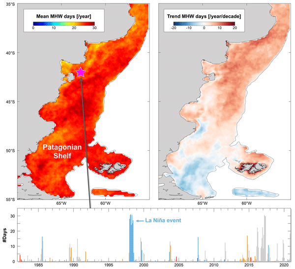
Abstract: Marine heatwaves (MHWs), have doubled in frequency globally in recent decades and are becoming longer, more intense, and increasingly disruptive to marine ecosystems. However, despite their growing ecological and biogeochemical importance, major productive coastal systems remain understudied, particularly in the Southern Hemisphere. Here, we provide the first comprehensive characterization of MHWs across the Patagonian Shelf (PS), one of the most biologically productive marine regions on Earth, using 40 years of satellite-derived daily sea surface temperature (SST) data. We first assess how the choice of MHW detection method (fixed versus moving climatology) and SST-dataset selection affect MHW metrics. Then we quantify MHW frequency, intensity, duration, and long-term trends, revealing that the PS experiences on average 1.9 ± 2 MHWs yr−1 with a mean cumulative duration of 23–28 d yr−1 and an average intensity of 1.36 ± 0.3 °C. We show that MHW activity varies substantially across the region, with the northern sector and the outer shelf experiencing the most frequent and intense events (>2 events yr−1 and >2 °C). A notable increase in MHW days (+5–10 d per decade) is observed in the northern PS, whereas no significant trends are observed to the south (i.e., south of 48° S). These trends are consistent with background warming of the ocean in this region, suggesting a mechanistic link, whereby long-term warming enhances the likelihood of MHWs occurrence and duration. We further demonstrate that a component of MHW variability can be attributed to the El Niño Southern Oscillation, which exerts a stronger influence on the intensity of thermal anomalies than on the cumulative duration of the events. Together, these findings constitute the first comprehensive assessment of MHWs on the PS and provide essential insight for anticipating their ecological and climatic impacts in one of the Southern Hemisphere's key marine ecosystems.
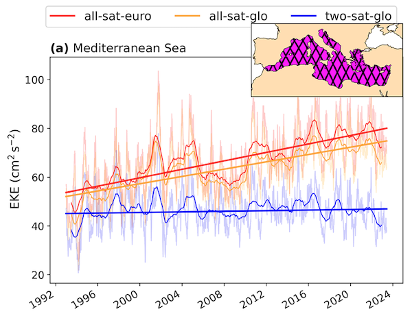
Abstract: Mesoscale activity plays a central role in ocean variability, substantially influencing the mixing of biogeophysical tracers, such as heat and carbon, and driving changes in ecosystems. Eddy Kinetic Energy (EKE), a metric used for studying the intensity of mesoscale processes, has recently been shown to increase in regions of intense EKE worldwide. Strong EKE positive trends are observed, for example, in the principal western boundary current regions, such as the Gulf Stream, Kuroshio Extension, and the Brazil/Malvinas Confluence. In this study, we assess whether the Mediterranean Sea, known to be a hotspot for climate change impacts, also exhibits such intensification. Despite the high number of observational data and modeling experiments, there is a gap in understanding the long-term evolution of mesoscale dynamics and EKE trends in the Mediterranean Sea. This study investigates EKE trends in the Mediterranean Sea using daily geostrophic currents derived from satellite altimetric data. To test the robustness of the results, we compare EKE trends computed from three different gridded altimetric products: a global product derived from a stable two-satellite constellation (two-sat) and two other products (global and European) incorporating all available satellites (all-sat). While all products reveal a general increase in EKE in the Mediterranean Sea over the last three decades, the trends calculated from the two-sat product are significantly smaller than those computed from the all-sat products. We show that this discrepancy is strongly linked to the increasing number of satellites over time used to construct the all-sat data sets, which enhances both spatial and temporal coverage, and hence, their capacity to detect higher energy levels. To evaluate the fidelity of these gridded products in capturing EKE trends, we compare them with along-track data in high-energy regions of the Mediterranean Sea: the Alboran Sea and the Ierapetra area. These regions exhibit contrasting EKE trends: positive in the Alboran Sea and negative in the Ierapetra area. These findings highlight the importance of using altimetric products with a stable number of satellites constructed for climate applications when addressing long-term ocean variability analysis.